Log in
All resources
Create a design
2,542 Free Artworks of Maps Of Paris
bibliothèque nationale de france
maps from gallica
atlas des anciens plans de paris by imprimerie nationale, 1880 from bhvp
maps by alexis-hubert jaillot
guides joanne
turgot map of paris, bibliothèque historique de la ville de paris
maps of alsace by guillaume sanson
géographie générale; physique, politique et économique (1876)
island of california
baroque
bibliothèque nationale de france
1667 sanson map of africa
bibliothèque nationale de france
1667 sanson map of africa
old maps of the kingdom of naples
lago patria
maps by alexis-hubert jaillot
old maps of toulouse
old maps of edinburgh
maps from gallica
old maps of el hierro
history of el hierro
atlas maior, vol 7 (france i) - joan blaeu, 1667 - bl 114.h(star).7
1667 maps
lawrence h. slaughter collection of english maps, charts, globes, books and atlases
nypl lionel pincus and princess firyal map division
maps from gallica
guides joanne
maps of paris in the 1910s
1910s maps of paris
maps of paris in the 1910s
1910s maps of paris
chambre des députés (july monarchy)
maps from gallica
merian plan of paris - derivative files
baroque
série 09. paris. hôpitaux et hospices
drawings in musée carnavalet
juan de la cruz cano y olmedilla
maps by tomas lopez
juan de la cruz cano y olmedilla
maps by tomas lopez
1870s maps of libya
ghadames
atlas des anciens plans de paris by imprimerie nationale, 1880 from bhvp
plan de turgot
maps in the library of congress
1690s maps of the world
old submaps of paris 6e arrondissement
gaston coindre
map of the upper rhenian circle by sanson
maps by nicolas sanson
maps of brest from bibliothèque nationale de france
lithographs of brest, france
bibliothèque nationale de france
sanson map of lorraine
tramways mécaniques des environs de paris
postcards of asnières-sur-seine
merian plan of paris - derivative files
baroque
atlas des anciens plans de paris by imprimerie nationale, 1880 from bhvp
dheulland map of paris
atlas des anciens plans de paris by imprimerie nationale, 1880 from bhvp
dheulland map of paris
maps from gallica
guides joanne
maps by louis brion de la tour
18th-century maps of tartary
maps of the course of the rhine by guillaume sanson
bibliothèque nationale de france
maps of alsace by guillaume sanson
1690s maps of baden-württemberg
theatre geographique du royaume de france (1632)
mercator 1587 world map
cartes generales de toutes les parties du monde (1658)
1650s maps of saxony
maps of alsace by guillaume sanson
1660s maps of alsace
maps of alsace by guillaume sanson
1690s maps of baden-württemberg
maps of alsace by guillaume sanson
1660s maps of baden-württemberg
maps of alsace by guillaume sanson
1660s maps of alsace
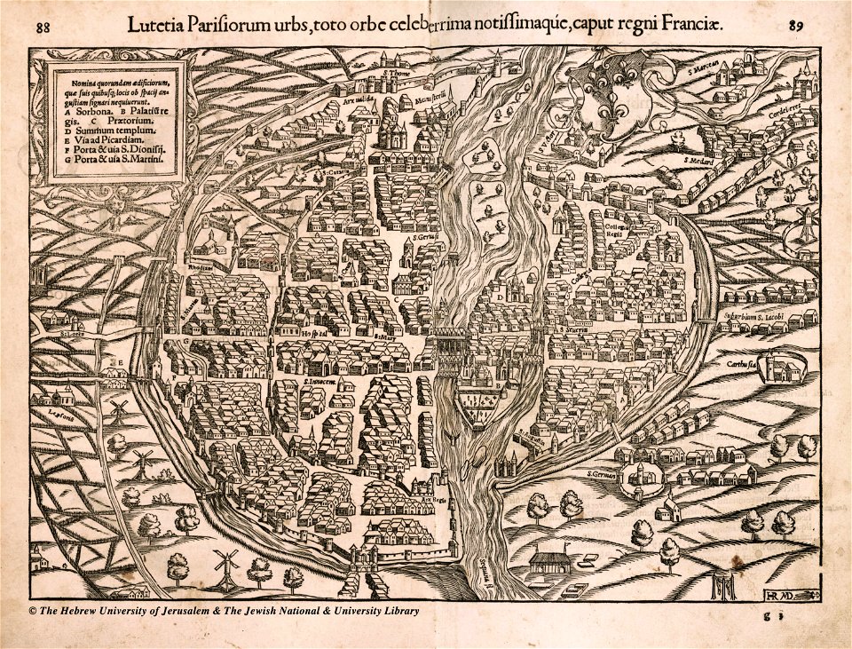
lutetia parisiorum urbs, toto orbe celeberrima notissimaque caput regni franciæ by sebastian münster
1670s maps of rhineland-palatinate
maps of vangiones by sanson
cartouches by alexis-hubert jaillot
17th-century maps of asia
géographie générale; physique, politique et économique (1876)
1870s maps of germany
nouvelle géographie universelle, vol. xii
old maps of la gomera
géographie générale; physique, politique et économique (1876)
1870s maps of china
maps by jan janssonius
atlas novus (blaeu)
considérations géographiques et physiques sur les nouvelles découvertes au nord de la grande mer
1750s maps of the russian empire
bibliothèque nationale de france
sanson map of lorraine
bibliothèque nationale de france
sanson map of lorraine
old submaps of paris 5e arrondissement
gaston coindre
prints of france in the universitätsbibliothek salzburg
wolf-dietrich-klebeband städtebilder
map of paris by claes jansz. visscher - derivate files
historical images of hôtel de ville de paris
first manned hydrogen balloon flight by jacques charles
benoît louis prévost
maps in the national library of australia
map of paris by claes jansz. visscher
guillaume-nicolas delahaye
jacques martin
the bottom of the sea (1870)
distance
maps by jean-baptiste bourguignon d'anville
18th-century maps of western europe
bibliothèque nationale de france
dheulland map of paris
theatre geographique du royaume de france (1632)
maps of perigord
atlas des anciens plans de paris by imprimerie nationale, 1880 from bhvp
turgot map of paris, bibliothèque historique de la ville de paris
atlas des anciens plans de paris by imprimerie nationale, 1880 from bhvp
turgot map of paris, bibliothèque historique de la ville de paris
atlas des anciens plans de paris by imprimerie nationale, 1880 from bhvp
turgot map of paris, bibliothèque historique de la ville de paris
atlas des anciens plans de paris by imprimerie nationale, 1880 from bhvp
turgot map of paris, bibliothèque historique de la ville de paris
turgot map of paris, kyoto university library – derivative files
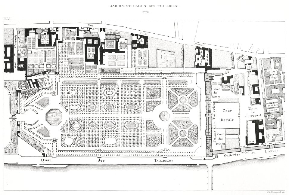
plans of the palais des tuileries
sanson maps of the netherlands
1700s maps of the netherlands
map collection of leibniz-institut für länderkunde
maps of spain by tomas lopez
map of paris by claes jansz. visscher - derivate files
île de la cité in art
map of paris by claes jansz. visscher - derivate files
collège des bernardins
18th-century maps of bretagne
robert cordier (engraver)
antoine-françois tardieu
maps from gallica
map of the circle of austria by sanson
maps by nicolas sanson
old maps of the kingdom of naples
maps by alexis-hubert jaillot
ambroise tardieu
bibliothèque nationale de france
guillaume sanson
antoine-françois tardieu
jean-baptiste poirson
french-language maps of south africa
1876 maps of africa
1876 maps of north america
1876 maps of the caribbean
1876 maps of the united states
old maps of new england
nouveau cours d'instruction primaire de géographie (1886)
1886 maps of france
old maps of atlantis
island of california
first manned hydrogen balloon flight by jacques charles
benoît louis prévost
old maps of finistère
maps from gallica
map of the circle of austria by sanson
1700s maps of austria
map of the circle of the rhineland by sanson
1730s maps of rhineland-palatinate
map of the circle of austria by sanson
1700s maps of austria
old maps of the republic of genoa
maps by alexis-hubert jaillot
eran laor cartographic collection
jean-claude richard de saint-non
maps from gallica
guides joanne
sanson maps of north america
1690s maps of north america
sanson maps of north america
island of california
sanson maps of north america
island of california
sanson maps of north america
island of california
maps from gallica
old maps of rouen
turgot map of paris – derivative files
rue de la tour-des-dames (paris)
le neptune francois
charles pène 8th
plan de paris d'ambroise tardieu - 1839
bibliothèque nationale de france
palais des tuileries before 1659
baroque
historical images of église saint-nicolas-du-chardonnet
baroque
carte des environs de paris (1905)
bibliothèque nationale de france
carte des environs de paris (1905)
bibliothèque nationale de france
maps of paris by braun & hogenberg
bibliothèque nationale de france
maps of the jardin des tuileries
lithographs of paris
901 - 1000 of 2,542
Next page
/ 26